Delhi Metro map
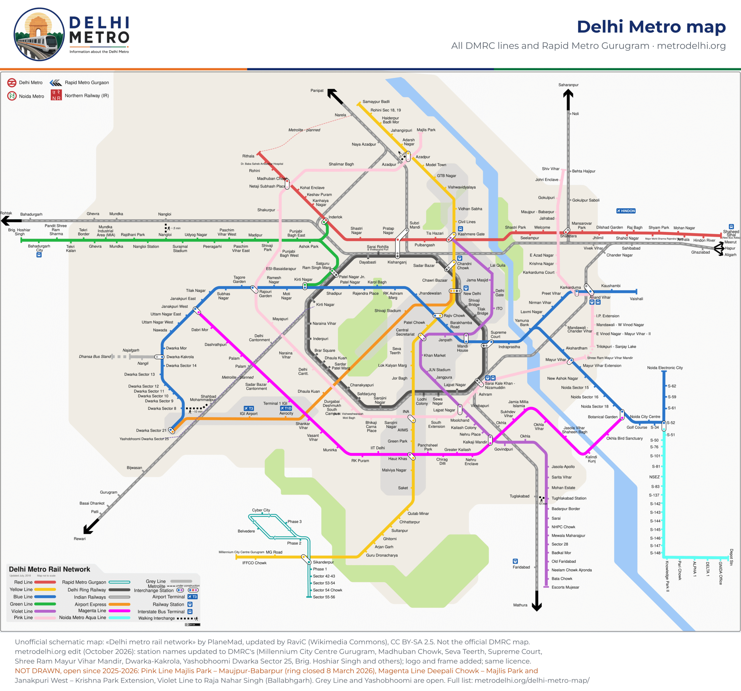
Every Delhi Metro line on one schematic map, with a PDF to download, and the changes since the map was drawn.
Delhi Metro map PDF
Delhi Metro map · PDF
Vector PDF, sharp at any zoom. Save it to your phone for when there is no signal.
What has changed since the map was drawn
The map is a free schematic last updated in 2018, and no free map of the 2026 network exists yet (the official DMRC map is copyrighted). We have updated the station names it shows; what it does not show yet is listed here, so you are not misled:
Renamed on our copy of the map
- HUDA City Centre is now Millennium City Centre Gurugram
- Pitam Pura is now Madhuban Chowk
- Udyog Bhawan is now Seva Teerth
- Mayur Vihar Pocket 1 is now Shree Ram Mayur Vihar Mandir
- Dwarka is now Dwarka-Kakrola
- Dwarka ECC – Sector 25 is now Yashobhoomi Dwarka Sector 25
- Pragati Maidan is now Supreme Court
- Sikandarpur is now Sikanderpur
- Bahadurgarh City Park is now Brig. Hoshiar Singh
- Rohini West is now Dr. Baba Saheb Ambedkar Hospital
Open but not drawn (or drawn as under construction)
- the Pink Line between Majlis Park and Maujpur-Babarpur (Burari, Jharoda Majra, Jagatpur-Wazirabad, Soorghat, Sonia Vihar, Khajuri Khas, Bhajanpura, Yamuna Vihar), which closed the ring on 8 March 2026
- the Magenta Line section Deepali Chowk – Majlis Park (opened 8 March 2026) and the extension from Janakpuri West to Krishna Park Extension (5 January 2025)
- the Violet Line stations beyond Escorts Mujesar: Sant Surdas (Sihi) and Raja Nahar Singh (Ballabhgarh)
- the Grey Line to Dhansa Bus Stand and the Airport Express to Yashobhoomi Dwarka Sector 25, both drawn as under construction but open
The line pages and the route planner on this site follow the network as it is today.
How to read the map
Each line has its own colour, the one DMRC uses on its signs and on this site. Interchange stations, where you change line without leaving the paid area, are drawn as linked white circles. The map is a diagram, not a street map: distances are not to scale.
It also shows the Noida Metro Aqua Line (NMRC, with its own tickets; the walk between Sector 52 Noida and the Aqua Line’s Sector 51 is outside both systems) and Indian Railways lines, which are not part of the Delhi Metro.
| Line | Stations | Route |
|---|---|---|
| Red | 29 | Shaheed Sthal (New Bus Adda) – Rithala |
| Yellow | 37 | Samaypur Badli – Millennium City Centre Gurugram |
| Blue | 57 | Dwarka Sector 21 – Noida Electronic City; Yamuna Bank – Vaishali |
| Green | 24 | Kirti Nagar / Inderlok – Brig. Hoshiar Singh |
| Violet | 34 | Kashmere Gate – Raja Nahar Singh (Ballabhgarh) |
| Pink | 46 | ring through Majlis Park; Maujpur-Babarpur – Shiv Vihar |
| Magenta | 33 | Krishna Park Extension – Botanical Garden; Majlis Park – Deepali Chowk |
| Grey | 4 | Dwarka-Kakrola – Dhansa Bus Stand |
| Airport | 7 | New Delhi – Yashobhoomi Dwarka Sector 25 |
| Rapid | 11 | Sector 55-56 – Sikanderpur – Cyber City loop |
Frequently asked questions
Stations, first and last trains, running times, frequencies and fares on this page come from the information the Delhi Metro Rail Corporation (DMRC) publishes on delhimetrorail.com (station pages, journey planner, fare and train-frequency pages), checked on 20 October 2026. metrodelhi.org is an independent guide, not run by DMRC or affiliated with it. Check delhimetrorail.com or the DMRC helpline before you travel.